|

 VISFLOOD 0.8 Beta
(with the 2D flood propagation demo)
VISFLOOD 0.8 Beta
(with the 2D flood propagation demo)
VISFLOOD 0.8 Beta User Manual (MS
Windows Help format) which includes tutorials on the use of the
software

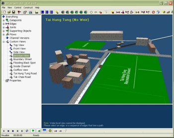
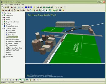
Tai Hang Tung Storage Tank Scheme (THTSS)
The Tai Hang Tung Storage Scheme (THTSS)
is an essential component of the West Kowloon Drainage Improvement
- Stage 2 Project that is being implemented to solve the flooding
problem in Mongkok, Hong Kong. Instead of digging up roads and
widening/adding existing drains, an innovative and economic
upstream storage scheme is devised. The plan calls for the
construction of a 100,000 m3 underground storage tank
below an existing football field. Under design conditions (maximum
flow of 110 m3/s), part of the flood flow along the Tai
Hang Tung Road culvert (approx. 8 m wide by 2.5 m high) and Tat
Chee Road culvert will be intercepted by a system of side weirs.
The storm water that overflows into the underground tank will be
temporarily stored; the flow diversion/storage serves to attenuate
the flood peaks and prevent downstream flooding.
A physical model is used to complement the dynamic wave model, and
to study the detailed design of the side weir and junction
arrangements. Both the numerical model results and physical model
tests show that the THTSS can significantly improve the flood
control capacity of the urban storm water drainage system. They
also confirm the key features of the flood attenuation, including
a predicted back flow from the Boundary Street Nullah into the Tai
Hang Tung sewer and the side weir channel overflows. The water
level at the flooding black spot is decreased by nearly 1 m.
 THTSS - No Weir
(wmv format, 7.51MB)
THTSS - With Weir
(wmv format, 9.12MB)
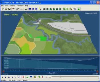
2D Flood Propagation
To simulate the 2D overland flow due to the overflow from a river or open
channel, a 2D diffusive wave model is dynamically coupled with the 1D
channel flow modelling engine developed for VISFLOOD. This demonstration
program uses a section of River Indus in the New Territories, Hong Kong to
illustrate the water flow in the river and flood plain adjacent to the
channel during a significant rain storm.
With the same navigation operations in VISFLOOD for 1D channel system,
users can interactively navigate around the modelled area in 3D
after installing and running the demo module.
Flood plain (River Indus, Hong
Kong)
(mpg format, 3.17MB)
|